Loading... Please wait...
- Home
- GPS Fishfinder Navigation
- GPS, Fishfinder & Autopilot
- Other Brands
- Navionics NAUS006R USA SOUTH Navionics+ 010-C1369-30 mapping for GPS finderfinder
Categories
- HOME
- ATV - UTV Parts (4 Wheeler)
- BBQ-Cooler-Kitchen-Appliances
- Boat Accessories: Deck-Cabin
- Boat Inboard I/O Engine Parts
- Boat Outboard Engine Parts
- Boat Steering & Control
- Motorcycles Dirt/Super Bikes
- Electrical
- Engine Maintenance Parts
- Fishing
- Fuel: Tank-Filter-Sender-Parts
- General Boating
- GPS Fishfinder Navigation
- Hardware
- Jetboat & PWC Watercraft Parts
- Maintenance & Care
- Paint & Accessories & Tools
- Plumbing: Pumps-Parts-Fittings
- RV Camper Outdoor Hitch Tow
- Propellers-Skeg Guard-Anodes
- Sailing-Sailboat
- Snowmobile Parts
- Sports & Recreation & Clothing
- Stereo Receiver Speaker Amps
- Trailer Parts Trailering
- Trolling Motors & Accessories
- Used Parts
- Used & Remanufactured Engines
- Ventilation: Blower-Hatch-AC
- Others


)

Product Description
DESCRIPTION:
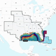
NAUS006R U.S. South Navionics+
Get the world&rsquos No. 1 choice in marine mapping with the best most up-to-date Navionics+ cartography on your compatible chartplotter.
For offshore or inland waters this all-in-one solution offers detail-rich integrated mapping of coastal waters lakes rivers and more. Get SonarChart 1&rsquo (0.5 meter) HD bathymetry maps advanced features such as dock-to-dock route guidance technology live mapping and Plotter Sync to provide wireless access to daily updates.
The Navionics Chart Installer software also ensures the freshest chart data every time out. Navionics dock-to-dock route guidance solutions give you a suggested path to follow through channels inlets marina entrances and more. Multiple shading options aid in shallow water navigation and make it easy to highlight a target depth range for the best fishing spots.
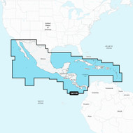
Chart Code NAUS006R
Coverage Area:
Coverage of the lakes rivers and coasts of Alabama Arkansas Florida Georgia Kansas Louisiana Mississippi Missouri Nebraska New Mexico Oklahoma Tennessee and Texas. Coastal coverage of the Gulf of Mexico the Atlantic coasts of Florida and Georgia the Bahamas and the Florida Keys are also included.
Features:
- Nautical Chart &ndash Comprehensive charts are derived from multiple officials government and private sources displayed in a familiar look and feel
- SonarChart HD Bathymetry Innovative 1' (0.5 m) bathymetry charts are created by using Navionics proprietary systems that augment existing content with sonar data contributed by the boating community
- Community Edits Get useful local knowledge from edits made by users of the Navionics Boating app on your compatible smart device.
- Daily Updates Up to 5,000 daily updates to our charts give you the most accurate most current Navionics data available.1
- Dock-to-dock Route Guidance2 Start your trip with a suggested path.
- SonarChart Live Mapping Watch new HD depth maps develop in real-time as your boat moves through the water.
- Advanced Map Options Customize your view to focus on the details that matter most
- Plotter Sync1 Transfer routes and markers update chart layers and more between your compatible chartplotter and the Boating app.
Compatibility:
- Check the compatibility of Navionics+ content and features with your GPS chartplotter.
Technical Specifications:
- Format SD/MSD Card
In the Box:
- SD/MSD Card
1Subscription not required for SonarChart Live mapping feature on some chartplotter models requires latest chartplotter firmware release.
2Dock-to-dock Route Guidance is for planning purposes only and does not replace safe navigation operations.
*Navionics+ and Platinum+ cards are not compatible with Garmin chartplotters.
*Sold as an Individual
This product may not be returned to the original point of purchase. Please contact the manufacturer directly with any issues or concerns.Manufacturer Part Number: 010-C1369-30
Internal Code: 92608
Need more info?
Ask a question.
We answer questions quickly....